
Charta Cosmographica: A 16th-Century Celestial and World Map by Apian, Frisius, and Gaultherot
Source: https://www.davidrumsey.com/
The Authors and Their Contributions
Peter Apian (1495-1552)
Peter Apian, a German cartographer, mathematician, and astronomer, was a pioneering figure in 16th-century scientific circles. Known for his work on astronomical instruments and cosmography, Apian sought to make complex astronomical and geographical knowledge accessible to the general public. His most famous work, Cosmographia, first published in 1524, laid the foundation for much of the subsequent maps and charts that followed. Apian’s approach was to merge practical geography with theoretical astronomy, making his work indispensable for both navigators and scholars.
Gemma Frisius (1508-1555)
Gemma Frisius, a Belgian mathematician and astronomer, collaborated with Apian to refine and update his Cosmographia. Frisius, who was deeply involved in cartographic innovations, made crucial additions and improvements, including the addition of new geographical details and celestial charts. His work on longitude determination, using the moon’s phases for navigation, marked a significant leap in the accuracy of maritime mapping.
Vivant Gaultherot (Publisher)
Vivant Gaultherot, a Parisian publisher, was instrumental in bringing Charta cosmographica to the public. His expertise in distributing scholarly works ensured that Apian and Frisius' contributions reached a broad audience in Europe. The Parisian edition of Cosmographica Petri Apiani in 1553 became one of the most famous versions of the work, adorned with woodcut illustrations and new details that captured the imagination of contemporary readers.
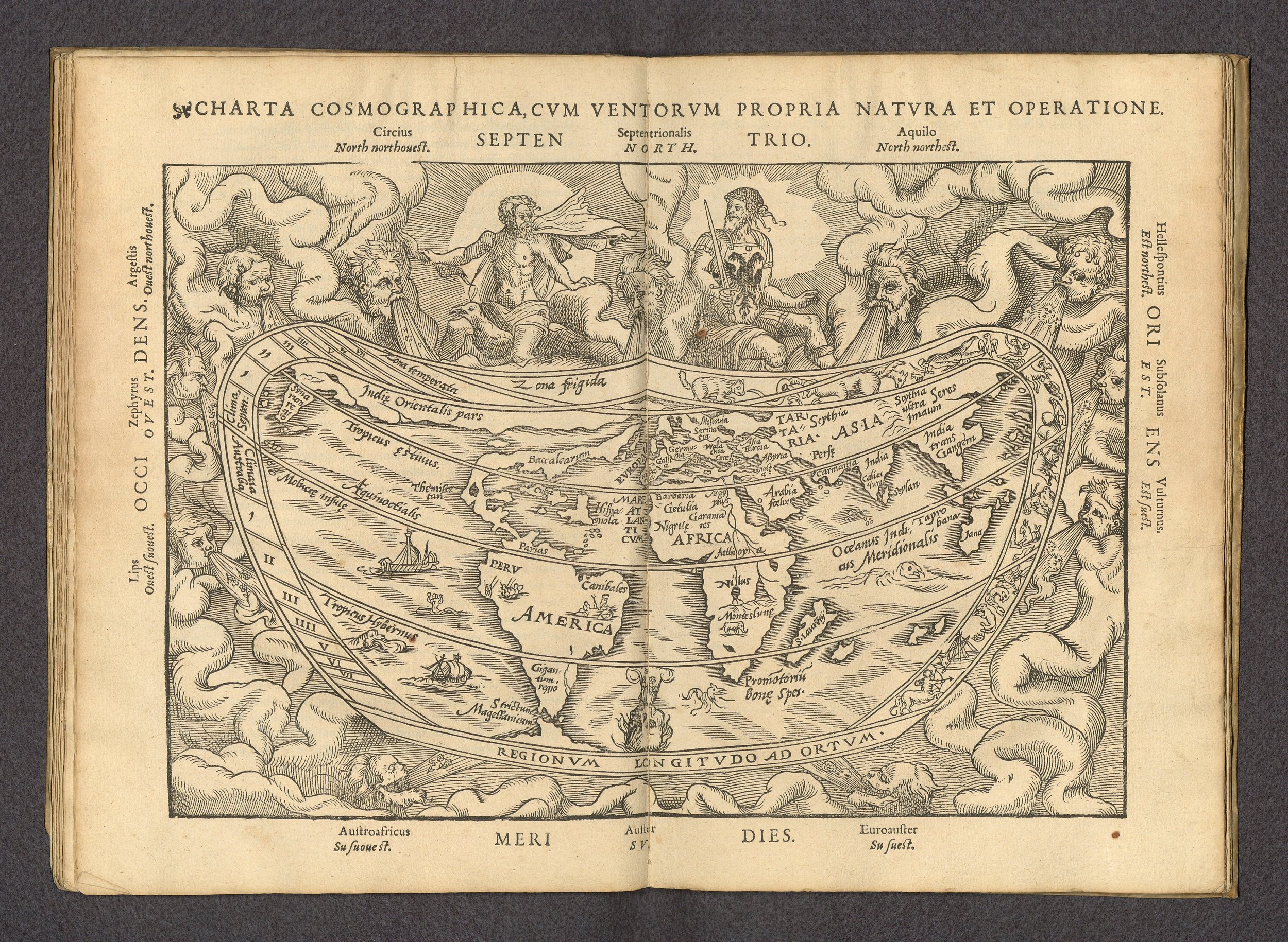
The Charta Cosmographica and Its Features
Published in Paris in 1553, Charta cosmographica is a woodcut map that stands out for both its artistic style and its scientific content. Measuring 19 x 18 cm on a sheet of 25 x 33 cm, the map is characterized by its rounded rectangular shape, a feature uncommon in the traditional square or circular world maps of the time.
One of the most striking elements of the map is its decorative border, which features zodiac symbols that emphasize the celestial aspect of the map. Surrounding the map are illustrations of human figures blowing wind toward the world, an artistic representation of the winds that were believed to affect weather and navigation in the early modern period. These illustrations, along with the directions listed in the margins, reflect the map's purpose not only as a geographical tool but also as a celestial and meteorological reference.
In terms of content, the map is a fascinating snapshot of the world as it was understood in the 16th century. The world map, despite its artistic flourishes, incorporates the geographical knowledge of the time, including an early representation of South America. This depiction reflects new discoveries from the Age of Exploration, with Apian and Frisius contributing updated details based on the latest reports from explorers.
Astronomy and Navigation on the Map
The Charta cosmographica is not merely a world map but also a celestial chart. It highlights astronomical concepts such as the movement of the planets and the zodiac signs, offering a visual connection between geography and the cosmos. Apian’s work in particular was influenced by the Ptolemaic model of the universe, where Earth was at the center, surrounded by concentric spheres containing the Moon, Sun, and other planets.
The map’s emphasis on wind gods and the depiction of volvelles, turning dials used for astronomical calculations, shows the significant role that both geography and astronomy played in navigation and exploration. Apian was one of the first to create tools that allowed for the calculation of longitude based on the movement of the moon, an essential skill for sailors and navigators.